If we want to cycle safely and bicycle to become a dominant transportation system in our 15-minute cities, we need to change. This means we should do the same as we did for road safety with seat belts or speed limits. All the innovations up to the driving license with penalty points have led to a very significant decrease in accidents, thanks to a mix of solutions: road safety, proper driver behaviour and road conduct, and vehicle modification. It is therefore important to consider all components. The patent of the Politecnico di Milano “Method for processing navigation information for road traffic” is an innovation designed to be a part of the change towards the safety of all bikers in urban areas.
The idea
The patent was born as a new navigation system but is aimed at reducing the likelihood of accidents in urban areas. The principle stemmed from an observation on the places where bicycle or motorcycle accidents mainly occur, i.e., basically near road intersections. The unfortunate situation of a car hitting a cyclist occurs at road intersections more often than on roads with good visibility… Indeed, what really matters is visibility. The project team therefore began studying and tackling the problem of visibility by analysing the dangers of road intersections, typically in urban areas.
Indeed, the urban context usually includes complex configurations of streets and many intersections: streets that intersect in a thousand different ways, roundabouts, several streets converging into the same point, street articulation, i.e., the positioning of streets at different angles that make visibility impossible, and obstacles or elements that aggravate the situation, e.g., parked cars. All these increase the potential accident rate in urban areas.
How it works
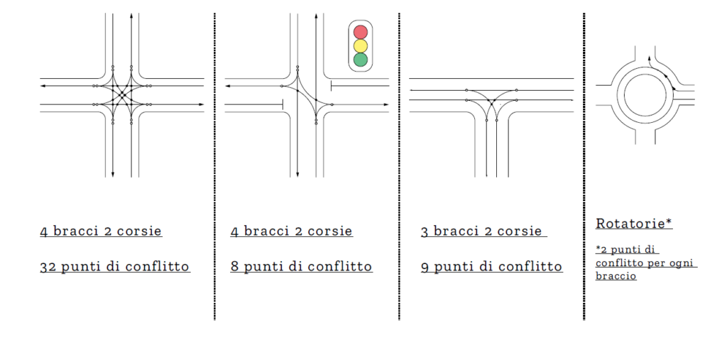
A system was studied based on the idea of evaluating the number of connections and intersections along a given route, and capable of calculating (using an algorithm) and displaying the user the hazard index of the road he/she is traveling. The conflict points construction mechanism for each intersection enables to evaluate the danger level of bicycle crossings.
For example, in Milan a typical street has two sides, both with two-way traffic, with a tramway lane in the middle. This means that there is an X number of conflict points; therefore, when you make a turn or cross the street, there are many points of extreme hazard, such as roundabouts or non-orthogonal junctions, with incident angles that are almost parallel and which cannot be seen… The device combined with a traffic monitoring system produces two data, i.e., the actual danger level and the variable traffic index, thus giving a complex index that really tells you what awaits you along your cycling route. So now we have a system specifically designed for bicycles that can be extended to electric bikes, electric scooters, scooters and motorcycles.
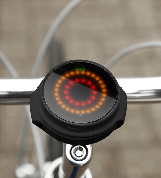
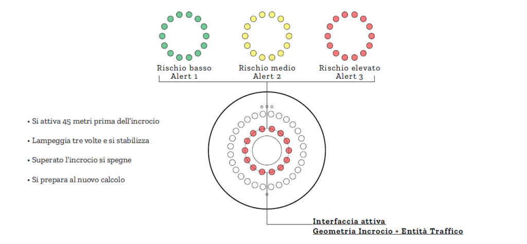
The patent consists of a demonstrated proof, an experimental element and the navigator with three gradient colours. Just like in Google, colours are used to display the danger index of the intersection you are approaching, which is calculated based on your movement speed: green means low risk, orange medium risk, red high risk red… The system functions as a warning system rather being a mere navigation system. This is a physical device, a sort of compass on your handlebar, a real prototype.
From the physical to the virual device
The patent covers the algorithm that controls the information you enter in the physical device placed on your bike handlebar. The device is used as a digital interface, so it is no longer a physical device: it is a digital one. Data processing is the same as that of the physical device and the digital display has the same functions as the physical one; the difference is that we do not need to manufacture it physically and it is already available to everyone.
There is a working prototype, a proof of concept showing that this type of mechanism generates this connected risk index, on which a real programming should be built to make the device a functional solution to all intents and purposes.
The idea is that the patent can be licensed to someone who wants to make a digital mask for current navigators and navigation systems for bicycles. This means combining material physical experimentation and a concrete device, but by patenting the algorithm. What we are trying to do is to transfer the patent for creating the hazard calculation mechanism and therefore have an additional layer to be added to current navigation systems. Just like the one that alerts you of the presence of speed cameras, the navigator could have a “bicycle switch” which uses route calculation to increase the safety level, suggesting routes that are less efficient and perhaps longer but are safer, thus minimising the risk of an accident.
Applications
The patent is an aid to safe navigation that allows you to choose the least risky cycling route: this is prevention. This means a route that is the most efficient while also being the least risky! It is designed for the circulation of bicycles and all two-wheelers in urban areas.
Benefits
Benefits extend to a set of technical components that concern safety. The system works regardless of road or weather conditions. Furthermore, it uses the geometry of the road to calculate a risk index of the street the biker is approaching, and then perfects it by integrating data on external factors.
The research Team
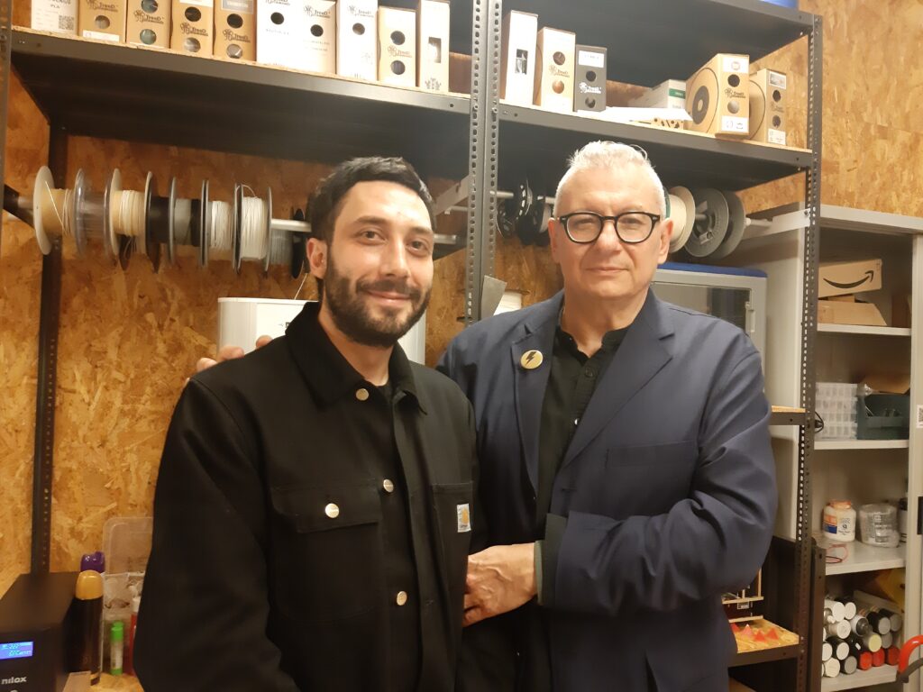
The Team is made up of the Designer Gianni Garaguso, who used this idea for his thesis and developed the patent together with the Director of Polifactory, Stefano Maffei, and his colleague Massimo Bianchini from the Politecnico di Milano.