“I remember that moment clearly. It was 8 February, 2021, I had got up early as usual. I had a shower, then I had breakfast. Around 7 o’clock I received a message from Professor Eugenio Morello. All he wrote was: “Nicola”… Then: “!!!”. Eugenio is the Supervisor of the project for the Politecnico di Milano. I rushed to the department and together we reread the email from the European Commission that announced my project had won the Marie Skłodowska-Curie call. In the end I hugged Morello, picked him up and ran round the laboratory with him. Due to the emergency situation caused by the pandemic, the laboratory was empty. It was just the two of us”.
Nicola Colaninno, researcher of Politecnico di Milano, is talking about the moment when he realised that the efforts he had made during his career and throughout his lifetime had been worth it. The moment when he found out that he had won the prestigious Global Postdoctoral Fellowship of the Marie Skłodowska-Curie call promoted by the European Commission. And that he would receive funding of over 250,000 euro for his project MultiCAST. Almost a year since that day, just a few months before the project officially commences (1 May 2022) we interviewed him for Frontiere.
Hi Nicola. First of all, what exactly will you be working on?
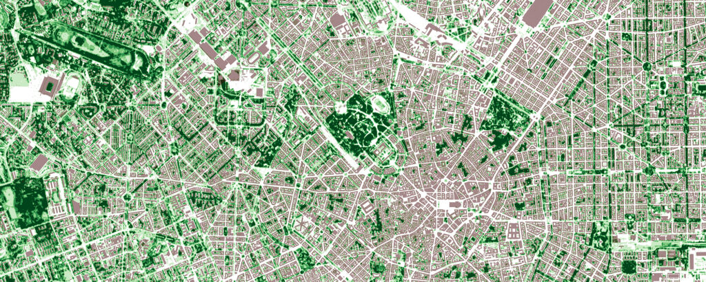
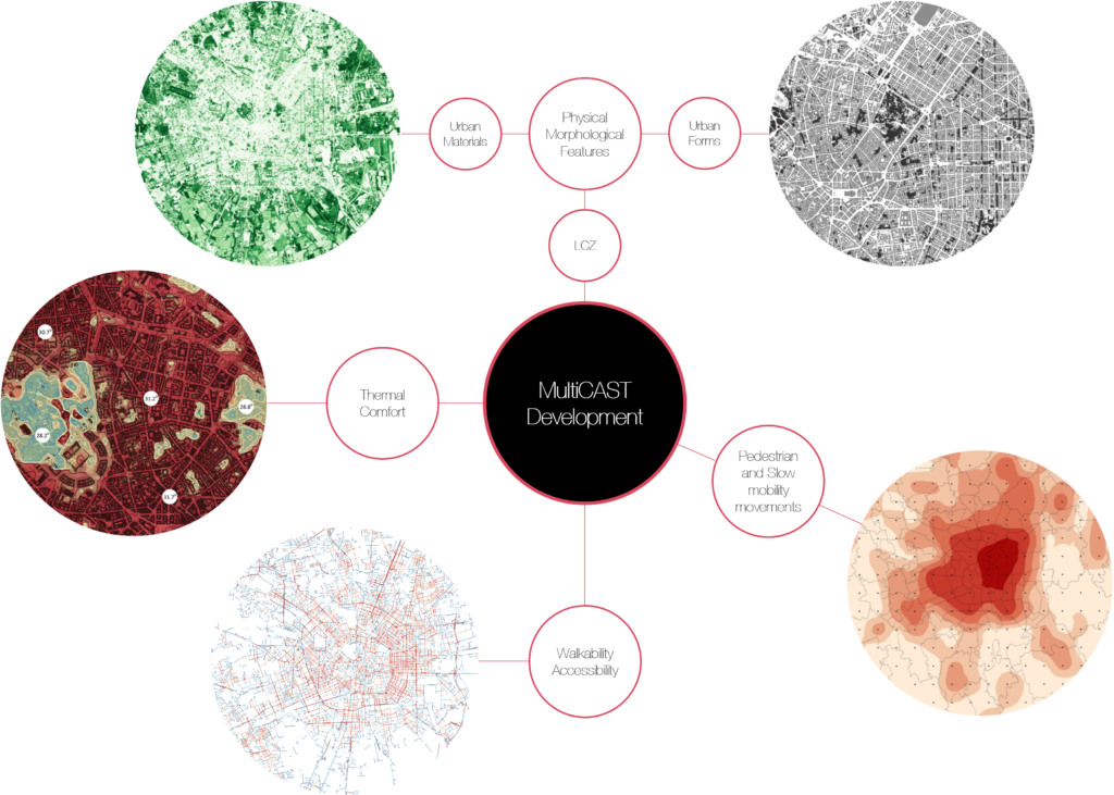
The MultiCAST project (Multiscale Thermal-related Urban Climate Analysis and Simulation Tool) will tackle the phenomenon of the Urban Heat Islands. Its aim will be to measure and mark out the critical areas, with a view to providing a tool for supporting the decisions to be made, both in terms of planning and urban policies, and therefore work on the ability to adapt in the cities. The system will be tested on three cities: Los Angeles, Amsterdam and Milan.
So you’ll be looking at the issues of climate change and global warming, two of the major challenges for the years to come…
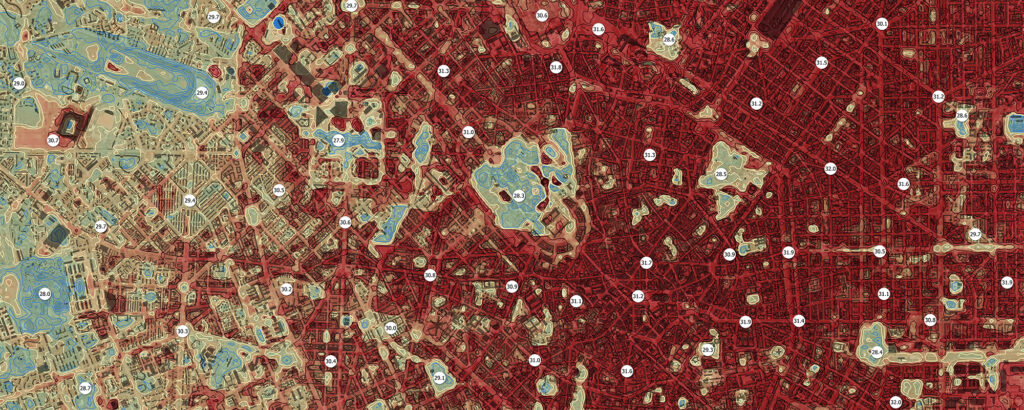
Yes, exactly. Regardless of the international agreements in place, carbon dioxide emissions and global warming are still increasing. Urban areas are subject to higher temperatures than peri-urban, agricultural or natural areas. This means that the intensity of the heatwaves in urban areas is “exasperated”, due to the physical and morphological components of the buildings. This dynamic, during periods of heatwaves (which are becoming increasingly frequent and intense over the last few years) threatens the health, comfort and wellness of citizens and city users. My project, funded by the European Commission as part of the Horizon 2020 programme, will adopt a “geo-spatialised” analytical approach to map the urban climate. The mapping activity will be used to build a system that supports the decisions and plans implemented to protect the climate, and for adaptive urban design. The main focus will be on mobility and accessibility for pedestrians and cyclists.
So, if we’ve got this right, thanks to this research project, in the future when we enter a destination into a navigation app, as well as telling us the fastest route, it could also indicate the “coolest” one.
Yes, this is one of the possible scenarios. And there have already been similar experiences. For example, in Paris, where, using a digital tool, during heatwave periods, the suggested routes are not necessarily the fastest ones, but the “coolest” ones, based on various criteria, such as, in this case, level of thermal comfort. We could talk about a kind of “accessibility based on thermal comfort”. In the case of the MultiCAST project, the objective is to design a digital tool that will support the decisions to be made. The original idea for which the funding was awarded concerns the systemisation of “classic” accessibility analyses, related to distances, and measurements of thermal comfort calculated in heatwave periods. Specifically, a well-known thermal comfort indicator such as UTCI – Universal Thermal Climate Index – will be considered, which measures the human physiological response, taking into account not only the temperature, as objective data, but also the perceived sensation.
Since it’s a Global Fellowship, is there a period of training in a third country?
Exactly. The project has a three-year duration, of which the first two years are the outgoing phase, spent with a host in a third country; the third year includes an incoming phase with the beneficiary organisation which, in my case, is Politecnico di Milano. The main host will be the Massachusetts Institute of Technology (MIT), Boston, where most of the research will take place: it will span 18 months of the first two years. I will also spend two brief periods, as a visiting researcher, in other European institutions. The project will officially commence on 1 May, when I will leave for Barcelona for the first 3 months, and where I will collaborate with a SME that I have involved in this initiative. In August I’ll go to Boston for 18 months, as mentioned. After that, there will be another three months, to complete the first two years, which I’ll spend at TU Delft in the Netherlands. From May 2024, I’ll be at the Politecnico for the last year of the project.
Winning this prestigious fellowship in “global” modality is also a great result for the Department of Architecture and Urban Studies. The partnership with the MIT, the coordination of the project at Politecnico di Milano, the large amount of funding… How are you feeling?
Yes, it really was a great result and it is confirmation that commitment, perseverance and passion pay off… or at least I hope so! I worked on the presentation of the project for most of 2020, in parallel with my activity as a researcher in the Fausto Curti Urban Simulation Laboratory. I remember locking myself in the house in August 2020 and working on the project for days on end, only allowing myself five days holiday at the beach. Those were five wonderful days, I have to admit… But that’s another story… [he smiles]. On the other hand, when I would take a break from working I would overwhelm my parents with my thoughts on the project that they deemed “too complicated”…
This is the dream of a lifetime come true. I set off many years ago from a tiny village with a population of seven thousand in the province of Taranto – Palagianello, it has a funny name – to study, firstly in Rome, for my Laurea in Architecture, then in Barcelona, where I also worked for several years but, above all, where I did my Ph.D., in urban studies and GIScience. During my Ph.D., I was also a visiting Ph.D. student at the University of Amsterdam. But here, at Politecnico di Milano, I found my ideal environment and I was able to crown my dream.